New website for Parkview Mountain House
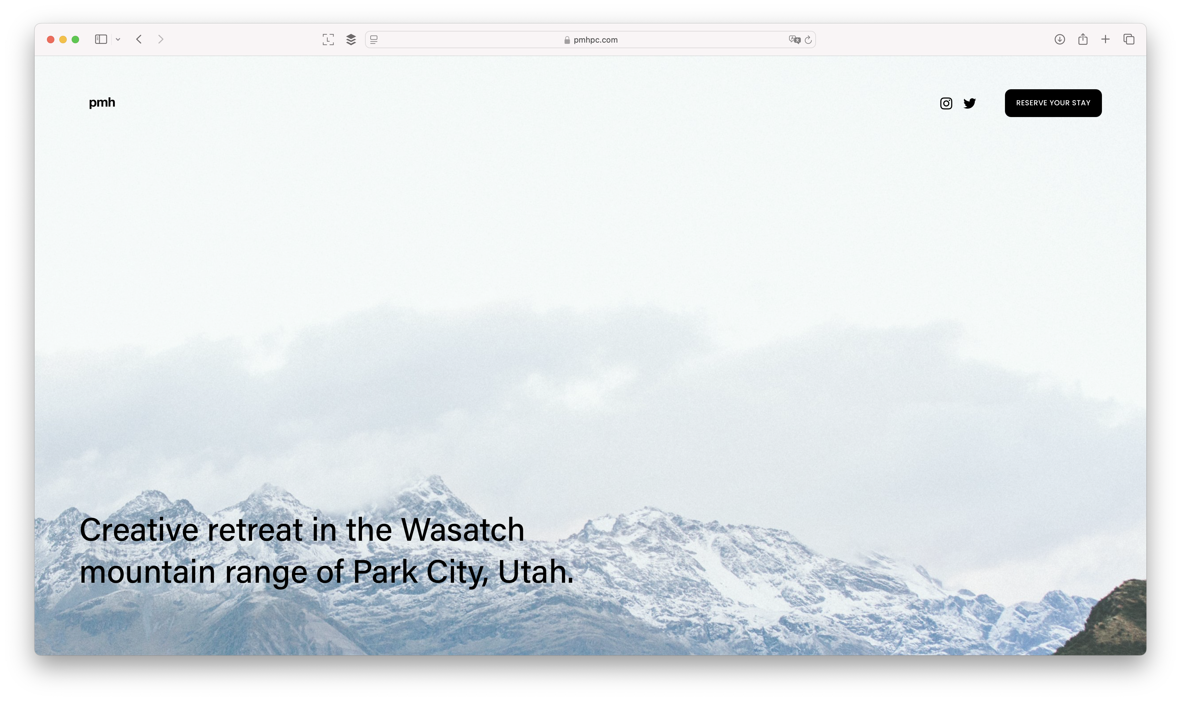
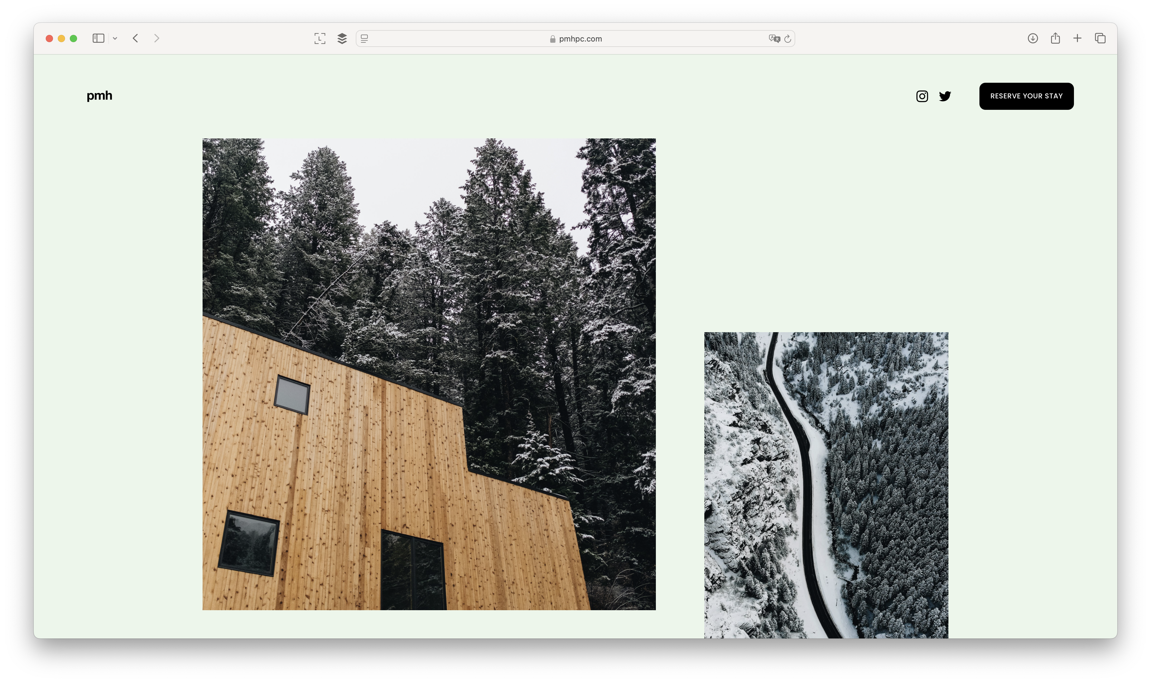
We just did a complete overhaul of the landing page for Parkview Mountain House.
If you're a new reader, PMH is Globizen's "creative retreat" in Park City, Utah. We completed it and opened it up for reservations at the end of last year.
If any of you have feedback on the new page, I'd love to hear it. It was a lot of fun rummaging through all of the photos that I have taken there over the years during development and construction.
And as much as I love snowboarding, I also really enjoy visiting during the summer months. It's a close second. This year my plan is to get down there for some road biking.
Desert responsive car-free urbanism
This month's issue of Monocle magazine is a special edition focused on property. And that's because this month was also the annual MIPIM festival in Cannes, which is apparently the largest real estate boondoggle, I mean conference, in the world.
One of the development projects that is featured in the special is Culdesac Tempe (which is located just east of Phoenix). This is a development that has received a lot of press over the years, including here on this blog, as it was developed as a car-free neighborhood in a city region known for the opposite.
But to be fair, it does have some parking.
There are 150 parking spaces (all surface) for 760 homes. So a parking ratio of just under 0.20 spaces per suite. This is still a remarkably low figure compared to what I would expect in Phoenix, which would be something closer to 1 to 1. I'd be curious to know how it's leasing/performing.
The entire development was also designed to be responsive to Arizona's climate. The buildings are close together so they shadow the circulation spaces, and no asphalt was used anywhere in the project in order to minimize heat retention. The architect for the project, Dan Parolek, refers to this as "desert responsive urbanism."
I'd love to visit one day, but until then, there's YouTube. Here's a full walkthrough by Kirsten Dirksen.

Waymo and Lyft now have the same market share in San Francisco
In August 2023, when Waymo first launched its self-driving vehicles in San Francisco, the market shares of Uber and Lyft were 66% and 34%, respectively.
By the end of last year, these market shares had dropped to 55% and 22%, respectively, with Waymo on equal footing with Lyft. (These numbers specifically refer to rides that start and end within the boundaries of where Waymo operates and do not, for example, include rides to the airport.)
So the result was low double-digit losses in market share for both companies. This is not all that surprising given that autonomous vehicles are a novel thing and that Waymo's cars seem to be nicer than most Ubers and Lyfts. But it also shows that there maybe isn't a great deal of customer loyalty between the various platforms, that is, as long as the wait times are reasonable.
I think the more difficult questions remain: What does the ride-hailing space look like as AVs become more ubiquitous across our cities? Who is going to own what? And will individual car ownership fall?
We've spoken before about the peak load problem that Waymo faces as a result of owning its own cars. It's expensive to manage a fleet like this, especially relative to Uber's variable supply model. So one scenario remains a close partnership between Waymo and Uber, where Uber handles any above-base spikes in demand with actual humans.
But another scenario might be a hybrid approach where some of the AVs are owned by a ride-hailing company and some are owned by individuals who just contribute them to the network when they don't need them. This is what Tesla has been promising and, who knows, maybe it'll actually happen someday. Reilly Brennan recently wrote about this over here.
Personally, I would love to not own a car. It's also hard to imagine being able to make much money off a car that only goes to work during peak times, when the other robots are too busy. So I'm not convinced of this model. But I can see why Waymo is gaining market share. Privacy and a nicer cleaner vehicle are desirable features.
Cover photo by gibblesmash asdf on Unsplash
New Vipp guesthouse opens in Tasmania


Eleven years ago, Danish homeware company Vipp opened its very first guesthouse in Sweden. Called Vipp Shelter, the house is a 55 m2 prefabricated steel pod that, today, can be rented starting from EUR 1,500 for two nights. Since then, Vipp has gone on to build and open 10 other guesthouses around the world and they have all been widely celebrated for their designs.
Now, if you look on their website, you'll see that they describe their guesthouses in the following way: "Not a hotel. Not a showroom. Not like any place you've ever stayed." This is mostly true, but they are also like showrooms for the company. And I've always found this to be a clever strategy, because what better way to experience a brand then to live with it for a few days in some beautiful locale.
Their latest guesthouse is called Vipp Tunnel (pictured above) and it's located in the Tasmanian bush. In case you're interested, it opened this week for bookings.
Photos via Vipp
How "viager" transactions work in France
In the 9th century, France enacted into law a way to buy and sell property through something known as une vente en viager. My understanding is that there are other European countries that also allow this, but that it's most popular in France, even if it still forms a relatively small portion of the market.
Here's how it typically works. You're an older person (or older couple) and you want to use your home to generate some cash, but you also want to stay living in your home until the very end. So you offer it up for sale en viager occupé. (This is the most popular option, but there's also le viager libre, where the seller moves out immediately.)
Whoever buys it will usually pay you, the seller, in two ways. They will pay you an upfront lump sum (called le bouquet) and a recurring payment (called la rente viagère) up until the day you die (or both of you die). Once this happens, the buyer then gets full enjoyment of the property. The transaction is complete.
So why would either party want to sell and buy in this way?
Well, if you're the seller, the obvious benefits are that (1) you get to continue living in your home and (2) you get some money now and for the rest of your life. This can be useful if you, say, run out of cash during retirement. It's a means to financial independence.
For buyers, it's the opportunity to maybe acquire a property below its current market price. Because if you don't have access to the home until some undetermined date in the future, well then a discount will obviously need to be applied. The initial lump sum payment is often around 30% of the current value. The other attractive feature is that it's a form of financing for buyers who may not have all the money they need today.
In the end, this is a bet on life expectancy. Because if the seller ends up living for a really long time, then they get the benefit of more annuity payments. However, if they end up living fewer years than expected, then the buyer benefits from having to pay less in annuity payments. They got to buy below market.
It's a fascinating pricing and time-value-of-money exercise, but it's also a potentially morbid way to buy real estate. On the one hand, you could be helping someone live a dignified retirement. On the other hand, you stand to benefit if they die sooner than expected.
Cover photo by Zach Dyson on Unsplash
Single stair sessions
One of the things I included in my list of "how to improve the feasibility of infill housing" was the adoption of single-stair buildings. So today I'm happy to share that next week the Canadian Urban Institute — in collaboration with LGA Architectural Partners — will be hosting a series of online micro-conferences covering this topic. If you're a regular reader of this blog, you'll know that LGA is one of the leading voices, if not the leading voice, advocating for this important building code change.
Here are the event posters:


And here are the links if you'd like to register for any of the sessions:
Single Stair Sessions Day 1 — "The 3 Ps: Pilot Projects and Prototypes"
Single Stair Sessions Day 2 — "The 2 Ss: Safety and Sustainability"
CityTalk | Live — "Addressing Canada's Housing Supply: Can Regulations Drive Housing Innovation?"
We are actively underwriting new missing middle housing across central Toronto. And I can tell you that project feasibility would benefit enormously from this code change. Single-stair buildings are also allowed in many/most other parts of the world, and so we already know that it can make for better homes and that it doesn't need to compromise life safety. It's great that the city-building community is now increasingly focused on this opportunity.
Cover photo by Mika Wegelius on Unsplash
Urban highways as urban barriers
Here is an interesting study that looked at the impact of urban highways on social connections within the 50 largest US cities. To measure this, the researchers used Twitter data from 2012-2013, which is a period of time where the default setting in the mobile app was to tag each tweet with the user's precise geographic coordinates.
This allowed the team to generally figure out where a user is likely to live. If you're often tweeting from the same residential address, then there's a good chance that's home. They then looked at things like mutual followship as a measure of social ties. And what they ultimately found was that in all 50 cities, urban highways exhibit a strong barrier effect. They measured this using something they call a "barrier score."

Now this sounds right and supports lots of other evidence that highways divide cities; but Twitter isn't necessarily a place where mutual followship means you actually know the person in real life and you regularly walk down the street to see if they can come out and play. So one of the things that the researchers also did was work to replicate their findings using data from another social network called Gowalla.
I very vaguely remember this platform, but it is/was a social network where users are supposed to connect with people they actually know and share their locations through check-ins. With this data they found that their "barrier score" was even more pronounced, which makes sense given that the platform's social graph should have had, in theory, stronger real-life ties.
But even if you don't believe the social data, these results should make intuitive sense. Highway underpasses and overpasses tend not to be the best environments for pedestrians. They're usually a clear break in a city's urban fabric, which can make people second guess whether they really want or need to cross it.
Cover photo by Tom Barrett on Unsplash
The biggest developer in Paris today is the mayor
The other night, I went down a Parisian real estate rabbit hole on Twitter. And one of the things that kept coming up was this half joke: The biggest developer in Paris today is the mayor. The reason for this is that the city is targeting 40% of all homes to be public housing by 2035 (of which 30% will be social housing and 10% will be moderately affordable).
Supposedly this is to stem the steady outflow of people from the capital as a result of housing being too expensive. But it means that a lot of new public housing will need to be created. As of January 1, 2021, the official estimate was 260,563 "logements sociaux" in the capital, which translates into 22.4% of all principal residences.
To hit this 40% goal, the city is going to need to create somewhere around 140,000 new public housing dwellings between now and 2035. So how does it plan to do this? By being a developer, of course. A big part of the strategy seems to be to convert existing buildings (d'adapter l’existant). And to execute on this, the city is leveraging something known as "le droit de préemption."
The way it works is like a right of first refusal clause (ROFR), except that it's not something that was contractually negotiated between market participants, it's just the law. What it means is that if a property owner goes to sell their building and they receive an offer, the city has an automatic ROFR and can choose to buy the building at whatever that third party was willing to pay.
Over the last two years, the city has elected to do this 84 times and has spent over €1.1 billion, according to Business Immo. And since the beginning of this year, they've done it 9 times, spending about €67 million on the following properties:

For those of you who are visual learners like me, here's the first property on the list:

It's certainly ambitious.
But, for the most part, it does not create a lot of net new housing, even though the city is also aiming to buy office buildings, parking garages, and other non-residential buildings. APUR previously estimated that for every 1 unit of new public housing, 0.6 existing units are being demolished. So the most accurate way to think about this initiative is that it represents the socialization of Paris' housing stock into public hands.
This runs in contrast to what we've been talking about recently with cities like Minneapolis and Austin, who have instead added a lot of new market-rate housing in order to temper rents and increase affordability. Paris is reducing its stock of market-rate housing.
At the same time, the city also enacted new policy prohibiting homes that consume more than 450 kWh/m2 from being rented. This is intended to force landlords to renovate, but it will certainly have a further impact on supply, at least in the short term.
It's also worth noting that all of this is happening at a time when Paris' housing market is in broad decline (less transactions, higher days on market, lower prices, and so on). Like Toronto, it started around the middle of 2022. And it's something that Paris hadn't seen since the 2008 financial crisis.
Chart by CoStar via Business Immo; cover photo by Salomé Watel on Unsplash
Minneapolis is urbanizing
Since 2009, policymakers in Minneapolis having been implementing land use changes to encourage more housing supply. Some of these changes have included eliminating parking minimums, encouraging multi-family buildings up to 6 storeys on commercial corridors, establishing height minimums in high-density zones, and permitting triplexes on all residential lots. It's, from what I can tell, the type of stuff that many cities have now done or are looking to do. But it seems to have worked remarkably well in Minneapolis. According to The Pew, between 2017 and 2022, the city issued permits for nearly 21,000 new homes and nearly 87% of them were for homes in buildings with 20 or more suites.
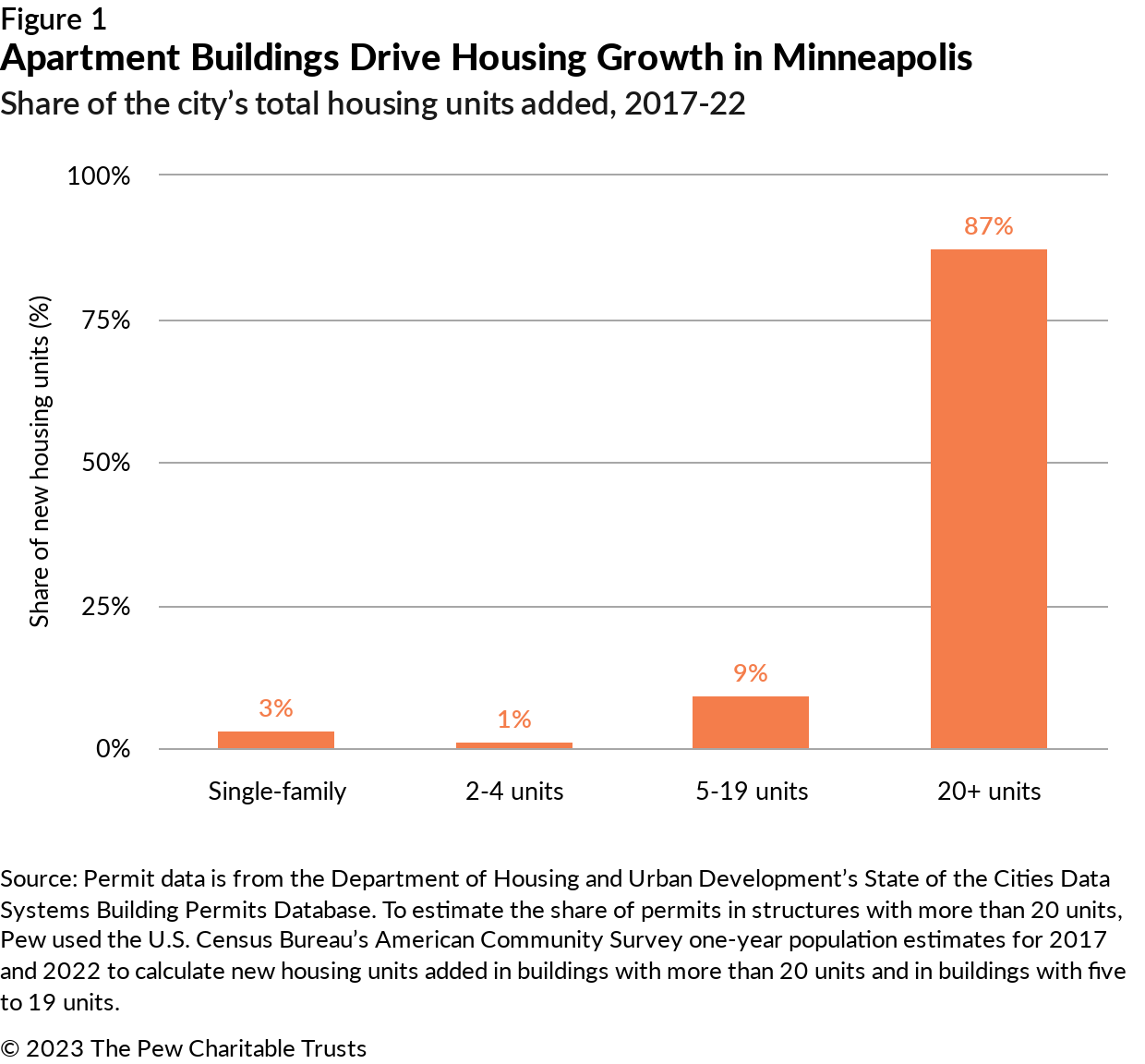
This is interesting. It tells us that the triplex policies don't seem to be doing all that much, but that the market has certainly taken to larger multi-family projects. This is an accomplishment. Even more importantly, though, is that it seems to be having a measurable impact on average rents. During the same time period as above, Minneapolis increased its housing stock by 12% and average rents increased by only 1%. Whereas the rest of Minnesota only increased its housing stock by 4% and, maybe as a result, average rents went up by 14%. Changes in homelessness also look dramatically different.

It looks to be a similar story to what's playing out in Austin: increased housing supply is tempering rent growth. (Okay, in the case of Austin it seems to be causing rents to fall.) What I would be interested in seeing now is a further breakdown of this 87% share. Because 20 suites is a different kind of build than 300 suites. It's different for developers and it's different for cities. And I'd like to know if the market is favoring one over the other, or if it's building apartments at all scales. If the city is in fact building lots of new apartments at multiple scales, then this is even more of an accomplishment. It means there might be no "missing middle."
Cover photo by Eastman Childs on Unsplash
Chinese architect Liu Jiakun awarded 2025 Pritzker Prize
Earlier this week, Chinese architect Liu Jiakun was awarded the 2025 Pritzker Prize. For those of you who may not be familiar, the Pritzker Prize is generally considered to be the architect world's most prestigious prize. (The full list of laureates can be found, here.)
Jiakun is based in Chengdu, China and he has worked exclusively within the country. His largest project is a mixed-use complex known as the West Village, which is a truly enormous courtyard building that exists at the scale of a neighborhood.
It houses cultural, recreational, commercial, and office spaces, all of which are connected by an elaborate network of pedestrian and cyclist ramps. Here's what that looks like from above:

At first glance, it's the kind of large-scale development that looks as if it may not work. It looks like it could be the kind of project that sterilizes a fine-grained urban neighborhood. But get closer, and things start to look a little different.

The true test is seeing how it performs at the scale of a pedestrian. And I found this walking tour helpful in understanding what that might feel like. If you spend a few minutes watching it, or even just scanning through it, you'll see that the area looks active and busy, even at night.
Now, I've never visited this project, or Chengdu for that matter, but I suspect that the way to think about this project is not as one giant complex, but as a giant public space flanked by buildings. In other words, it's not that the complex is enormous, it's that the public spaces are enormous.
Jiakun is quoted as saying this:
“I always aspire to be like water,” says Liu, “to permeate through a place without carrying a fixed form of my own and to seep into the local environment and the site itself. Over time, the water gradually solidifies, transforming into architecture, and perhaps even into the highest form of human spiritual creation. Yet it still retains all the qualities of that place, both good and bad.”
The West Village seems to be a testament to this approach. He aspired to not interrupt the flows of the existing environment, and perhaps that's why it works so well. Or at least, that's what it looks like on YouTube.
Photos by Qian Shen Photography